
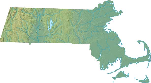
Massachusetts Relief Map
Static Massachusetts Relief Map
Interactive Massachusetts Relief Maps
The interactive relief map choices include a standard Google terrain map and an enhanced Google terrain map with Street View capabilities. To zoom in or out on either of these Massachusetts maps, click or touch its plus (+) button or its minus (-) button, respectively. To pan either map in any direction, simply swipe it or drag it in that direction. To display either of these Massachusetts terrain maps, click or touch one of the following menu options.
Massachusetts's highest mountain is Greylock Mount, whose peak is 3,491 feet above sea level. The largest lake in Massachusetts is Webster Lake. If you are planning a visit to Massachusetts, please see Massachusetts Vacation, the official state tourism site, where you can find a wide range of travel and vacation information. For information about Massachusetts history and recreational activities, visit the following National Park sites.
Massachusetts National Parks
- Adams National Historical Park
- Appalachian National Scenic Trail
- Blackstone River Valley National Heritage Corridor
- Boston African American National Historic Site
- Boston Harbor Islands National Recreation Area
- Boston National Historical Park
- Cape Cod National Seashore
- Essex National Heritage Area
- Frederick Law Olmsted National Historic Site
- John F Kennedy National Historic Site
- Longfellow National Historic Site
- Lowell National Historical Park
- Minute Man National Historical Park
- New Bedford Whaling National Historical Park
- Salem Maritime National Historic Site
- Saugus Iron Works National Historic Site
- Springfield Armory National Historic Site
Copyright © 2005-2024 State-Maps.org. All rights reserved.
Massachusetts-Map.org is a State Maps reference source.
To facilitate browsing, certain external links will open in new windows.
Massachusetts-Map.org is a State Maps reference source.
To facilitate browsing, certain external links will open in new windows.