
Massachusetts Map
|
 |
 |
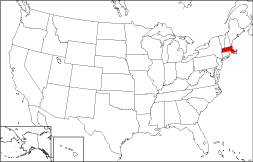
Where Is Massachusetts?
On the adjacent map, the location of Massachusetts is highlighted in red. The Commonwealth of Massachusetts is bounded by New Hampshire on the north, by Connecticut on the south, by the Atlantic Ocean on the east, and by New York on the west. It is bounded by Rhode Island on the southeast, and by Vermont on the northwest.
Massachusetts Maps
Massachusetts is the 45th largest state in the United States, and its land area is 7,840 square miles (20,306 square kilometers). Massachusetts is subdivided into 14 counties. This Massachusetts map site features road maps, topographical maps, and relief maps of Massachusetts. The detailed, scrollable road map displays Massachusetts counties, cities, and towns as well as Interstate, U.S., and Massachusetts state highways. The pannable, scalable Massachusetts street map can be zoomed in to show local streets and detailed imagery.
Massachusetts Highway Map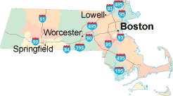 Click on the highway map thumbnail
to view a scalable Massachusetts road map. |
MA Topo Map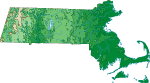 Click map to enlarge.
|
MA Relief Map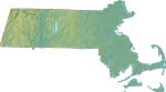 Click map to enlarge.
|
The detailed Massachusetts map and the regional Massachusetts map display cities, roads, rivers, and lakes as well as terrain features. The detailed map shows only the Commonwealth of Massachusetts, while the regional map shows Massachusetts and the surrounding region.
Massachusetts Infrastructure > Massachusetts Airports
In 2005, the population of Massachusetts was estimated at 6,433,367, which is about 816.2 people per square mile. In 2010, Massachusetts' population rose to 6,547,629 people. More recently, in the 2020 census, the Massachusetts population was 7,029,917. Massachusetts is one of the most densely populated states in the USA. Interstate Highways in the Commonwealth of Massachusetts include I-90, I-91, I-93, I-95, and auxiliary route I-495.
Massachusetts Topography and Attractions
Massachusetts was named for the Massachusett Indian tribe who lived south of Boston in the Great Blue Hill region. The name Massachusett means "at the great hill". Eastern Massachusetts is a low-lying coastal plain, the Connecticut River flows southward through central Massachusetts, and the Berkshire Hills rise in the western part of the state. Other major rivers include the Housatonic, and Merrimack. Visitors come to see the historic sites in and around Boston, and to enjoy the Cape Cod shoreline. For Massachusetts travel and tourism information, visit the official Massachusetts tourism site and Massachusetts Atlas.
Other Massachusetts Maps
This online Massachusetts reference map shows major cities, roads, railroads, and physical features in Massachusetts.Several map publishing companies offer printed maps of Massachusetts. For example, Omni Resources offers several maps of Massachusetts that feature points of interest, airports, and parks, as well as selected local attractions and insets of major Massachusetts cities.
All rights reserved.
Certain maps hereon are © Map Resources or Digital Wisdom.
To facilitate browsing, certain external links will open in new windows.
Massachusetts-Map.org Editor, State Maps, PO Box 828, Barnegat, NJ 08005.